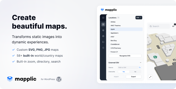
Mapplic is a WordPress plugin that turns ordinary images and SVG vector drawings into interactive maps and floor plans, without relying on tile-based services such as Google Maps. It is sold on CodeCanyon as part of the marketplace’s Utilities category, costs $189, and is developed by sekler. Mapplic Utilities suits site owners who need to map something that no street-map provider covers: a shopping centre interior, a hospital wing, a festival ground, a cruise ship deck, or a fictional world.
The product has been purchased 13,371 times and holds a 4.47 out of 5 rating across 307 reviews, which places it among the more established items in its niche. The vendor last updated it in December 2025, and it is declared compatible with WordPress 4.9 through 7.0.x, so it is not an abandoned script.
What the plugin actually does
The core idea is straightforward. Instead of plotting coordinates on a globe, Mapplic treats any image — a photograph of a building directory, an isometric illustration, a hand-drawn fantasy continent — as a map canvas. Points of interest are placed on top of that canvas as landmarks, and each landmark can carry its own pin, icon and action. That action might open a tooltip, reveal a detail panel, or jump to a different view entirely.
Several capabilities sit on top of that foundation and are worth separating out.
Landmarks, floors and deep links
Landmarks are the individual locations on a map, and the plugin does not cap how many can be created. Each one can be styled with a distinct pin or icon, which matters when a single map mixes categories — shops, toilets, exits and information desks all need to be visually distinguishable at a glance. Floors work the same way: there is no limit on how many stacked levels a single map can hold, so a multi-storey building can be presented as one navigable object rather than a series of disconnected images.
Deep linking is the feature with the most practical consequences. Every location can be addressed by its own URL, which means a business can send a customer a link that opens the map already focused on the right unit. Without it, a map is a destination users have to navigate themselves; with it, a map becomes something that can be shared, bookmarked and indexed.
Search, categories and filtering
Categories and searchable or filterable lists let visitors narrow a map down rather than hunting visually. On a large retail directory this is the difference between a usable tool and a decorative image. The vendor describes a filterable list as the mechanism by which someone locates a specific store, and that framing is accurate — the value scales with the number of landmarks, not with the size of the map.
Interaction and mobile behaviour
Zoom, pan, a minimap and tooltips form the interaction layer. The minimap is a small overview that shows where the current viewport sits inside the larger map, which becomes necessary once a user has zoomed in far enough to lose their bearings. Touch input is supported, so the same map works on a phone, a tablet and a touchscreen kiosk without a separate build. The plugin is declared compatible with Firefox, Safari, Opera, Chrome and Edge.
Built-in geographic maps
Mapplic also ships a directory of ready-made geographical maps, including a world map, world continents, Europe, the United States, Canada, Australia and a set of individual countries such as France, Germany, Italy, the United Kingdom, the Netherlands, Switzerland, Russia, China and Brazil. The vendor states the directory is being expanded with free additions including Austria, Belgium, Hungary, Japan, Mexico, Poland, Romania, South Africa and Spain. These are useful when a project needs a stylised country or continent map rather than a photographic one.
Administration and source files
Configuration happens through a WordPress admin interface rather than through code, which is the main reason the plugin is accessible to non-developers. A user guide is included. The package also ships with the original source files — JavaScript, JSON, HTML, CSS, PHP and layered PNG assets — so a developer who wants to extend or restyle the front end is not locked out. Layered PNGs in particular are the raw material for custom pins and markers.
Where Mapplic fits, and where it does not
The clearest fit is any project where the geography is private, invented or temporary. Shopping malls, hospitals, schools, airports and public buildings all need indoor floor plans that Google Maps cannot render. Ski resorts and isometric illustrations need a stylised, non-photographic look. Festivals, camps and other temporary sites need a map that exists for a weekend and then disappears. Cruise ships move, so their deck plans cannot live on a fixed coordinate system. Historical reconstructions and RPG or video-game worlds have no real-world counterpart at all.
A second fit is the agency or freelancer building the same kind of deliverable repeatedly. Because landmarks and floors are unlimited and the source files are included, one licence can serve many client projects of the same shape.
There is also a clear case against it. If a project needs real geographic accuracy — driving directions, live traffic, GPS tracking, routing between addresses, or a map that must stay in sync with OpenStreetMap data — this is the wrong tool. Mapplic renders a picture and layers interactivity on top; it does not perform geospatial computation. A tile-based mapping service or a dedicated store-locator plugin will be cheaper and more appropriate for that job. The same applies to anyone who needs a map generated automatically from a database of addresses on a schedule, since Mapplic maps are authored, not derived.
Strengths and limitations
Strengths
- Handles map types that mainstream mapping services cannot represent at all, including indoor floors, illustrated maps and fictional worlds.
- No cap on landmarks or floors, so the same licence covers a small directory and a large multi-storey building.
- Deep linking makes individual locations shareable and linkable, which is what turns a map into a usable navigation tool.
- Touch support and responsive behaviour mean one build covers desktop, mobile, tablet and kiosk.
- Source files are included, so developers can modify the front end rather than working only through settings.
- A long compatibility list and a recent update indicate active maintenance rather than a one-off release.
- 307 reviews at 4.47 out of 5 is a meaningful sample, not a handful of early ratings.
Limitations
- At $189 it is priced as a premium item, and there is no free tier to test the workflow before committing.
- It is not a geographic information system. There is no routing, no distance calculation and no live data feed, so any project needing those must look elsewhere.
- Maps are authored by hand in the admin interface. A site with hundreds of locations that change frequently will find the maintenance burden falls on a person rather than a database import.
- The built-in geographic directory covers a fixed list of countries. The vendor names the ones in progress, but the full set is not available today, so a project needing an unlisted country must supply its own vector artwork.
- Customisation beyond the admin options depends on comfort with JavaScript and CSS. The source files make that possible, not automatic.
- The vendor does not state performance characteristics for maps with very large numbers of landmarks, so heavy deployments should be tested before launch.
How it compares with the alternatives
Interactive map tools generally fall into three groups. The first is tile-based services — Google Maps, Mapbox, OpenStreetMap-based plugins. These excel at real-world geography, routing and address lookup, and they are the right answer when the map must correspond to actual coordinates. They are the wrong answer for interiors, illustrations and invented places, which is precisely the gap Mapplic occupies.
The second group is general-purpose page builders and image-mapping add-ons that let a designer place clickable hotspots on a picture. These are cheaper and lighter, but they typically stop at hotspots: no floors, no deep links, no filtering, no minimap, no structured landmark data. For a single decorative image with three clickable regions, that is sufficient and Mapplic is overkill.
The third group is specialist floor-plan and directory plugins aimed at a single vertical, such as mall directories or real-estate listings. These often ship with tighter integration for their niche but far less flexibility outside it.
Mapplic sits between the second and third groups. It is more capable than a hotspot add-on and more general than a vertical-specific tool, and it costs more than both. The decision rests on whether a project needs the specific combination of unlimited landmarks, multiple floors, deep linking and touch-ready interaction — because that combination is what justifies the price, and a project that needs only one of those four is probably paying for features it will not use.
Frequently Asked Questions
Does Mapplic work with Google Maps or OpenStreetMap data?
No. Mapplic renders its own images and SVG vectors rather than pulling tiles from an external mapping service. That is a deliberate design choice, not a missing feature, because it is what allows indoor floor plans, illustrated maps and fictional worlds to be mapped at all. Projects that need real-world coordinates should use a tile-based service instead.
Can Mapplic maps be used on a touchscreen kiosk?
Yes. The vendor states that maps are touch-optimised and that they function on tablets, smartphones and touchscreen kiosks. Zoom and pan respond to touch input, and the layout is responsive across screen sizes. The plugin is declared compatible with Firefox, Safari, Opera, Chrome and Edge, so browser coverage is broad.
Can a single location on a Mapplic map have its own link?
Yes, through deep linking. Every location can be referenced by its own URL, so a link can be shared that opens the map focused on that specific landmark. This is useful for directing customers to a particular store, room or point of interest without asking them to search the map manually.
Are the source files included with the purchase?
Yes. The package includes JavaScript, JSON, HTML, CSS, PHP and layered PNG files. That gives developers the ability to restyle or extend the front end rather than relying only on the admin settings. It also means custom pins and markers can be produced from the supplied layered assets.
Verdict
Mapplic is worth buying for anyone whose map does not exist on a street map: mall and hospital directories, campus and airport floor plans, festival grounds, ski trails, cruise decks, historical reconstructions and game worlds. The combination of unlimited landmarks, unlimited floors, deep linking and touch-ready interaction is what separates it from cheap hotspot add-ons, and the 13,371 sales and 4.47 rating suggest the approach works in practice. Buyers should not expect routing, live data or automatic generation from an address database, and should budget time for hand-authoring locations in the admin interface. Anyone who needs real geographic accuracy should choose a tile-based mapping service instead, and anyone who needs a single image with a few clickable regions will find $189 hard to justify.


